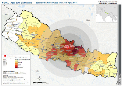
Earthquakes in Nepal 2015
In April and May 2015 Nepal was hit by devastating earthquakes that caused thousands of casualties and left even more in need for shelter, food and water, and further humanitarian support.

Without any official map material, the first response and the coordination of emergency procedures turned out challenging. Likewise to previous disasters, this problem was addressed by the international Humanitarian OpenStreetMap (HOT) community. More than 7000 volunteers supported the Nepal response by collecting and providing openly accessible OpenStreetMap data of the disaster affected regions using satellite imagery or through local mapping.
The data, including information about roads, buildings, helicopter landing sites, IDP camps, and level of damage, could be openly accessed in the OSM database and utilized by emergency repsonders, humanitarian aid organizations, and the affected population.
Further Information can be found here:
- http://wiki.openstreetmap.org/wiki/2015_Nepal_earthquake
- https://www.hotosm.org/projects/nepal_2015_earthquake_response
- http://www.seismonepal.gov.np/index.php?action=earthquakes&show=recent&page=5
OSM contributor activity
To get an impression of the impact that the work of thousands of volunteers had on OSM data in the Nepal region, a spatio-temporal distribution of contibutor activity has been computed. This was done using the newly developed OSM History Database from the Heidelberg Institute for Geoinformation technology (HeiGIT).
The values computed for the "OSM contributor activity of building edits" represent the sum of all changes to all buildings in a hexagon cell per month.
Changes represented in the value are:
- adding a new building
- changing the building geometry
- changing tags of buildings (ways or relations)
- adding/changing relation members in case of multipolygon
Acknowledgements
- Base Data: © OpenStreetMap contibutors, under ODbL
- Contributor Activity Analysis: Sabrina Marx, Lukas Loos, Michael Auer, Rafael Troilo, Martin Raifer
- Background Map Tiles: CARTO raster tiles "dark_all" © OpenStreetMap, ©CARTO
- Earthquake Information above: Melanie Eckle, Sabrina Marx
- OSM History Database: Rafael Troilo, Martin Raifer, Lukas Loos, Jiaoyan Chen, Moritz Schott, Michael Auer
- 3D-WebGIS Library: GIScene.js by Michael Auer
- Website: Michael Auer
Contact
GIScience Research Group
Institute of Geography
Heidelberg University, Germany
HeiGIT Project
Email: zipf[at]uni-heidelberg.de
Web: http://giscience.uni-hd.de/


